
Flag of Myanmar
| Legal Name | Republic of the Union of Myanmar |
|---|---|
| Flag |
|
| Capital City |
Naypyidaw |
| Total Area | 676,578 km² |
| Land Area | 653,508 km² |
| Water Area | 23,070 km² |
| Population | Approximately 55 million |
| Major Cities | Yangon (~5.2 million), Mandalay (~1.8 million), Naypyidaw (~1 million), Bago (~300,000) |
| Currency | Myanmar Kyat (MMK) |
| GDP | USD 85 billion |
| GDP Per Capita | USD 1,550 |
About of Myanmar
Myanmar is a Southeast Asian nation located at the crossroads of South and East Asia, sharing borders with Bangladesh, India, China, Laos, and Thailand, and a coastline along the Andaman Sea and the Bay of Bengal. The country’s diverse geography ranges from mountain ranges in the north and east, to fertile central plains, and tropical coastal regions. Its maritime access has historically facilitated trade and cultural exchange.
The capital, Naypyidaw, was established in 2005 as the administrative center, while Yangon remains the largest city and a primary economic hub. Myanmar is home to over 135 recognized ethnic groups, with a majority Bamar population. The country is a member of the United Nations, ASEAN, Non-Aligned Movement, and other international organizations. Its strategic location bordering two major powers, China and India, gives Myanmar considerable geopolitical significance, particularly in regional trade, energy corridors, and security.
Etymology
The name “Myanmar” derives from the Bamar ethnic group, which is the largest in the country. The historical term “Burma” comes from the Portuguese and British adaptations of “Bamar” or “Bama.” In 1989, the ruling military government officially changed the English name to Myanmar, reflecting a broader national identity beyond the majority ethnic group. The name signifies unity and sovereignty.
History
Prehistoric and Ancient Civilizations
Evidence of human settlement in Myanmar dates back to 10,000–6,000 BCE, with cave paintings and early agricultural communities. Ancient city-states along the Irrawaddy River emerged, cultivating rice and practicing early trade.
Classical and Medieval Periods
Between the 9th and 13th centuries, the Pagan Kingdom unified much of Myanmar, constructing thousands of Buddhist temples in Bagan. Subsequent centuries saw the rise of Mon, Shan, and Arakan kingdoms, contributing to cultural, religious, and architectural development.
Colonial and Imperial Rule
By the 19th century, Britain annexed Burma in three stages (1824–1885), incorporating it into British India. Colonial rule introduced modern administration, infrastructure, and plantation agriculture but also triggered nationalist movements.
Independence Movement
Following World War II, Burma gained independence from Britain on 4 January 1948, establishing a parliamentary democracy. Early post-independence years were marked by ethnic insurgencies and political instability.
Key Post-Independence Events
In 1962, a military coup led by General Ne Win installed a socialist military government, followed by decades of authoritarian rule. Democratic movements, including Aung San Suu Kyi’s National League for Democracy, emerged in the 1980s. The country experienced partial democratization in 2010–2015 but returned to military rule after the 2021 coup, resulting in internal conflict and international sanctions.
Government and Politics
Myanmar is currently under military administration, though it officially maintains a presidential system under the 2008 Constitution.
Executive: Headed by the President, with significant powers retained by the State Administration Council (military).
Legislative: Pyidaungsu Hluttaw (bicameral parliament), though military reserves 25% of seats.
Judiciary: Includes the Supreme Court, High Courts, and other tribunals; independence is limited under military oversight.
Myanmar is divided into 14 administrative regions, including states and divisions. Its foreign relations are shaped by ASEAN membership, relations with China and India, and international pressure on human rights issues. The Tatmadaw (military) maintains extensive control over defense and internal security.
Economy
Myanmar has an emerging economy with significant potential, yet constrained by political instability.
Major Industries: Agriculture, mining, oil and gas, garments, timber, and tourism.
Agriculture: Rice, pulses, beans, and fisheries are central to rural livelihoods.
Services: Banking, retail, telecommunications, and transportation are growing.
Natural Resources: Rich in gems (jade, rubies), oil, natural gas, and timber.
Major trade partners include China, Thailand, India, Japan, and Singapore. Challenges include underdeveloped infrastructure, sanctions, internal conflict, and limited foreign investment. Economic reforms aim to improve trade, diversify industry, and enhance energy and infrastructure sectors.
Demographics
Population Composition: Predominantly Bamar (~68%), with Shan, Karen, Rakhine, Chin, Kachin, Mon, and others.
Languages: Burmese (official), Shan, Karen, Rakhine, Chin, and other minority languages.
Religions: Theravada Buddhism (~88%), Christianity, Islam, and traditional animist practices.
Urban vs Rural: ~30% urban, with growth concentrated in Yangon, Mandalay, and Naypyidaw.
Population Trends: Moderate growth, impacted by migration and ethnic conflicts.
Culture and Society
Myanmar’s culture blends Buddhist traditions, indigenous customs, and colonial influences. Festivals like Thingyan (Water Festival) and Thadingyut (Lighting Festival) are widely celebrated. Traditional arts include Burmese puppetry, weaving, lacquerware, and temple architecture. Cuisine features rice, curries, fermented fish products, and tropical fruits. Football is the most popular sport, alongside martial arts and traditional games.
Education and Healthcare
Education is compulsory at the primary level, with literacy around 75%. Higher education is concentrated in Yangon, Mandalay, and Naypyidaw. Healthcare is underdeveloped, with public hospitals facing shortages. Major health challenges include malnutrition, malaria, tuberculosis, and COVID-19 impacts, though vaccination and public health campaigns have shown progress.
Geography and Climate
Myanmar’s geography features mountain ranges, river valleys, plains, and coastal regions.
Key Features: Irrawaddy and Salween Rivers, Shan Plateau, Rakhine Coast, and Andaman Sea.
Climate Zones: Tropical monsoon in the south, subtropical in the highlands, and temperate in northern mountains.
Natural Hazards: Cyclones, floods, landslides, and occasional earthquakes.
Environmental Concerns: Deforestation, mining impacts, water pollution, and loss of biodiversity.
Flora and Fauna
Myanmar has rich biodiversity, with tropical forests, mangroves, and wetlands. Notable plants include teak, bamboo, and orchids, while wildlife includes elephants, tigers, leopards, gibbons, and numerous bird species. Protected areas include Hkakabo Razi National Park, Inle Lake Wetlands, and Chatthin Wildlife Sanctuary.
Map of Myanmar
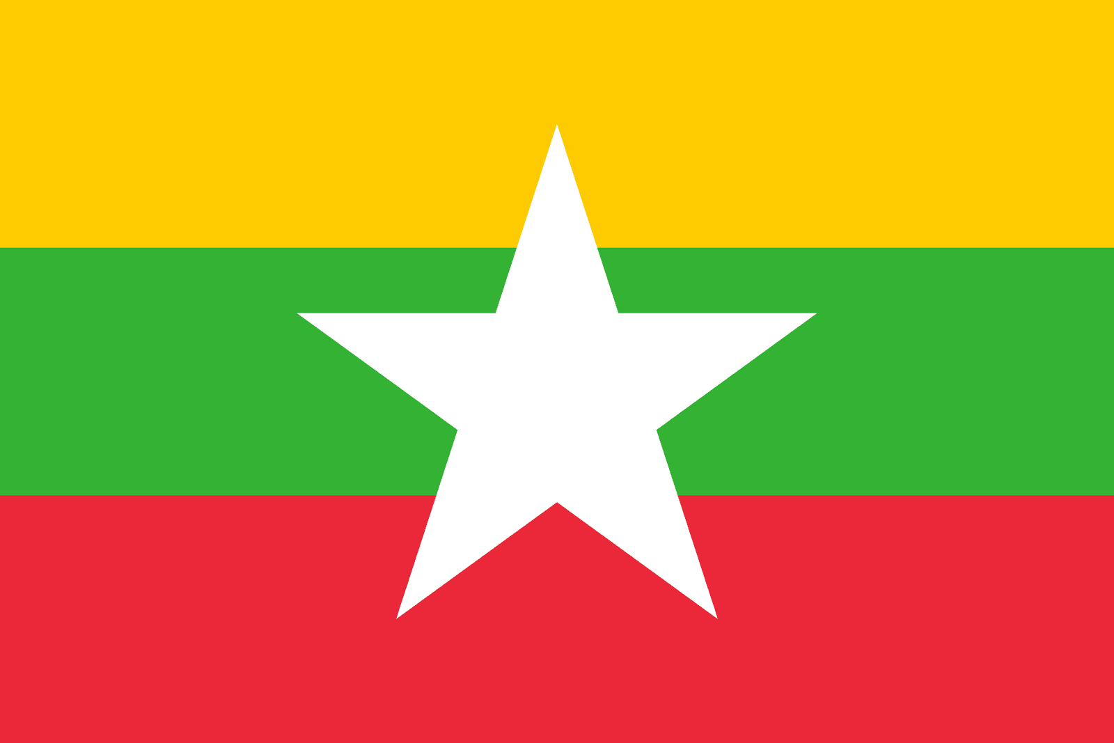
Flag: Yellow, green, red horizontal stripes with a central white star.
Coat of Arms: Features a traditional Burmese shield, lions, and peacock symbolizing heritage.
National Anthem: Kaba Ma Kyei
National Animals/Plants: Tiger, peacock, and padauk tree.
National Flag (Detailed Section)
The Myanmar flag was adopted on 21 October 2010. The yellow symbolizes solidarity, green represents peace and tranquility, and red signifies courage and decisiveness. The white five-pointed star represents the unity of the country’s diverse ethnic groups.
Flag Protocol: Flown on government buildings, schools, and official functions.
Usage: Represents national identity and unity.

Flag flying days
| Date | Flag Position | Occasion / Reason |
|---|
| 4 January | Full-mast | Independence Day |
| 12 February | Full-mast | Union Day |
| 27 March | Full-mast | Armed Forces Day |
| National Mourning | Half-mast | Death of national leaders or tragedies |