Flag of Suriname
| Legal Name | Republic of Suriname |
|---|---|
| Flag |
|
| Capital City |
Paramaribo |
| Total Area | 163,820 km² |
| Land Area | 156,000 km² |
| Water Area | 7,820 km² |
| Population | Approximately 611,000 |
| Major Cities | Paramaribo (250,000), Lelydorp (40,000), Nieuw Nickerie (30,000), Moengo (15,000) |
| Currency | Surinamese Dollar (SRD) |
| GDP | USD 5.3 billion |
| GDP Per Capita | USD 23,000 (PPP) |
About of Suriname
Suriname is located on the northeastern coast of South America, bordered by the Atlantic Ocean to the north, French Guiana to the east, Guyana to the west, and Brazil to the south. The country is characterized by vast tropical rainforests, rivers, and a narrow coastal plain where the majority of the population resides.
Paramaribo, the capital and largest city, serves as the administrative, economic, and cultural center. Other urban centers include Lelydorp, Nieuw Nickerie, and Moengo. Suriname has a diverse population, reflecting its colonial history, with people of East Indian, African, Javanese, Indigenous, Chinese, and European descent.
Internationally, Suriname is recognized as a sovereign state and participates actively in regional organizations, including CARICOM, the Union of South American Nations (UNASUR), and the Organization of American States (OAS). Its strategic importance lies in its mineral wealth, coastal ports, and role in regional environmental conservation.
Etymology
The name “Suriname” originates from the Surinen, an Indigenous people who inhabited the region prior to European colonization. The term evolved through Dutch and Portuguese colonial influence to denote the territory along the Suriname River, eventually becoming the country’s official name.
History
Suriname’s history begins with Indigenous settlements, primarily the Surinen, Arawak, and Carib peoples. European contact commenced in the 16th century with Spanish and Portuguese explorers, followed by Dutch colonization in the 17th century. Plantations producing sugar, coffee, and cocoa relied heavily on enslaved African labor.
In 1954, Suriname became a constituent country of the Kingdom of the Netherlands. A movement for full sovereignty culminated in independence on November 25, 1975. Post-independence periods included political instability, military coups in the 1980s, and social unrest. Today, Suriname maintains democratic governance and continues economic development while navigating challenges related to infrastructure, environmental conservation, and ethnic integration.
Government and Politics
Suriname is a constitutional democracy with a presidential system:
Executive: President serves as both head of state and government, elected by the National Assembly
Legislature: Unicameral National Assembly with 51 members
Judiciary: Supreme Court of Justice oversees judicial matters
The country is divided into ten administrative districts, including Paramaribo, Wanica, and Brokopondo. Suriname maintains diplomatic relations globally and engages in regional security and economic initiatives. The Surinamese Armed Forces are small, focusing primarily on internal security and border protection.
Economy
Suriname’s economy is classified as developing, with natural resources forming its economic backbone. Key sectors include bauxite mining, gold, oil, agriculture (rice, bananas, and shrimp), and forestry. Services, particularly in trade and finance, are growing in the urban centers.
Exports focus on minerals, oil, and agricultural products, while trade partners include the United States, the Netherlands, Brazil, and China. Economic challenges include dependency on commodity exports, infrastructure deficits, and inflation. Future growth relies on diversifying the economy, attracting foreign investment, and sustainable resource management.
Demographics
Suriname has a highly multicultural population:
Ethnic Groups: East Indian (Hindustani), African (Creole), Javanese, Indigenous, Chinese, and European
Languages Spoken: Dutch (official), Sranan Tongo, Hindi, Javanese, English, and various Indigenous languages
Religions: Christianity, Hinduism, Islam, and traditional beliefs
Urban vs Rural: Approximately 65% urban, concentrated in the coastal regions
Population Growth Trends: Moderate growth, influenced by emigration and urbanization
Culture and Society
Surinamese culture is a unique blend of Indigenous, African, Asian, and European influences. National identity emphasizes multiculturalism, religious tolerance, and ethnic coexistence. Arts include music genres like kaseko and kawina, traditional dances, and literature reflecting diverse cultural narratives. Cuisine combines Dutch, Creole, Indian, and Javanese flavors.
Festivals include Diwali, Eid al-Fitr, Christmas, and the Maroon Day celebration. Football, martial arts, and traditional games are popular sports.
Education and Healthcare
Education consists of primary, secondary, and tertiary levels, with Dutch as the primary medium of instruction. Literacy rates are high, and higher education is provided by institutions like Anton de Kom University of Suriname.
Healthcare is developing, with public hospitals and clinics covering major urban areas. Challenges include limited rural access, infectious diseases, and maternal health. Ongoing initiatives aim to improve infrastructure and public health coverage.
Geography and Climate
Suriname features coastal plains, dense tropical rainforests, and upland savannas. Major rivers include the Suriname, Marowijne, and Coppename. The country experiences a tropical rainforest climate with wet and dry seasons, high humidity, and limited temperature variation. Natural hazards include flooding and occasional coastal erosion. Environmental concerns focus on deforestation, mining impacts, and biodiversity preservation.
Flora and Fauna
Suriname is one of the most biodiverse countries in South America. Rainforests host mahogany, teak, and Brazil nut trees. Wildlife includes jaguars, tapirs, anteaters, and countless bird species. Marine ecosystems support diverse fish and coral species. Conservation is prioritized through national parks such as Central Suriname Nature Reserve and Brownsberg Nature Park.
Map of Suriname
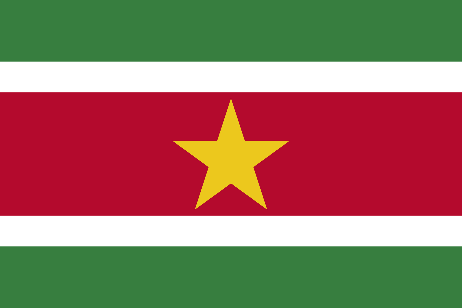
National Flag: Five horizontal stripes of green, white, red, white, and green with a central yellow star
Coat of Arms: Features a shield flanked by a pair of Indigenous men, a star, a ship, and a palm tree
National Anthem: God zij met ons Suriname
National Animals/Plants: Jaguar, Scarlet Ibis, Kapok tree
National Flag (Detailed Section)
The flag, adopted in 1975 at independence, symbolizes unity, hope, peace, and progress. The central yellow star represents national unity, while green denotes the country’s forests and agriculture, red represents progress and struggle, and white symbolizes justice and freedom. The flag is flown on government buildings, during national celebrations, and international representations.
Realted Flags

Flag flying days
| Date | Flag Position | Occasion or Reason |
|---|
| November 25 | Full-mast | Independence Day |
| February 23 | Full-mast | National Heroes Day |
| As Declared | Half-mast | National mourning or remembrance |